

El Niño and Ocean Climate Variability
Every few years the trade winds weaken, the warm water of the western Pacific spreads east, and the weather changes on every continent. This unit explains the normal tropical Pacific and the tilt of its thermocline, the Bjerknes feedback that lets a small push grow, the Kelvin and Rossby waves that end an event and set the rhythm of two to seven years, the indices and moorings by which El Niño is watched, the great events and their teleconnections, and how far ahead an El Niño can be predicted.
Every few years the trade winds over the Pacific weaken, the warm water that they normally hold in the west spreads eastward along the equator, and within months the rain fails in Indonesia, floods come to the desert coast of Peru, the Atlantic hurricane season turns quiet, and the global mean temperature sets a new record. No other feature of the ocean changes the weather of so many people so predictably. This unit explains how the tropical Pacific is held in its normal state, how a small push on it can grow into an El Niño, why the ocean itself stops the event and brings the next one two to seven years later, how the event is watched by moorings and satellites, and how far ahead it can be predicted.
1 The normal tropical Pacific
Unit 4 showed the pattern in the map of sea surface temperature. The warm pool of the western equatorial Pacific stays above 28 °C all year and reaches 29 to 30 °C north of New Guinea, while the cold tongue along the equator east of the date line is 23 to 24 °C, which is 5 to 6 °C colder on the same latitude under the same Sun. The difference is made by the wind. The trade winds blow from the east along the whole equatorial Pacific. They drive the surface water westward, and the Ekman transport of Unit 5 carries that water away from the equator on both sides, to the right of the wind north of the equator and to the left of it south of the equator, so that cold water is lifted from below in the east, where the thermocline lies close to the surface. The upper panel of Figure 1 shows the result in cross-section. The warm layer above the thermocline is about \(170\unit{m}\) thick at 165° E and only \(40\unit{m}\) thick at 110° W, and the sea surface stands about half a metre higher in the west than in the east.
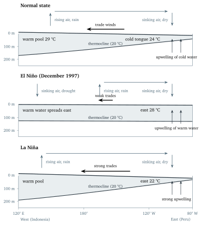
The atmosphere follows the sea surface. Over the warm pool the air is heated and moistened from below, rises in deep thunderstorms, and gives the region north of Australia and Indonesia more than \(2\unit{m}\) of rain a year. Over the cold tongue the air is cooled from below, sinks, and the coast of Peru is a desert on which years can pass without rain. Between the two, the air flows westward at the surface as the trade winds and returns eastward at a height of \(10\) to \(15\unit{km}\). This east-west overturning along the equator is the Walker circulation. It is the east-west counterpart of the Hadley cells of Unit 4, which overturn north to south, and the two together set the pattern of the tropical winds. The trades maintain the temperature difference, and the temperature difference maintains the trades, so the normal state is held by a loop in which the ocean and the atmosphere support each other; Section 2 shows what happens when the loop is disturbed.
1.1 Why the thermocline tilts
The wind cannot pile water up in the west for ever. As the warm layer thickens in the west, the pressure at any depth inside it becomes higher there than in the east, because the sea surface stands higher above that depth, and the pressure gradient pushes the warm layer back eastward. The layer thickens until this push balances the stress of the wind on the sea surface.