

Coasts, Estuaries, and Upwelling
The coastal ocean is shallow, stirred by tides and local winds, and fed by rivers, and most of what the sea does to people happens there. This unit explains why fresh water flows out over the sea and salt water flows in underneath, how a wind along a coast draws cold water up from 200 m and feeds the richest fisheries on Earth, why a storm raises the sea by metres on a wide shallow shelf, and how tide gauges and satellites measure the 20 cm the sea has risen since 1900.
Almost everything the ocean does to people, it does within a few tens of kilometres of a coast. The water there is shallow, it is stirred by the tide and by every passing wind, it carries the mud and the fresh water of the rivers, and its edge moves: twice a day with the tide, by metres in a storm, and by millimetres a year as the whole ocean rises. This unit follows the physics of Units 5, 6, and 9 to the shore. The same Ekman transport that builds the gyres draws cold water up from 200 m along the coasts of California and Peru and feeds the richest fisheries on Earth, the same balance of wind and pressure tilts the North Sea against the Dutch dykes, and the tide gauges that record the tide have, in two centuries of measurement, recorded the sea coming up.
1 Where the river meets the sea
An estuary is a semi-enclosed body of water on a coast that is open to the sea and in which seawater is measurably diluted by fresh water from the land. The definition, which most oceanographers have used since the 1960s, covers a river mouth, a drowned river valley such as Chesapeake Bay, a fjord, and, taken literally, the whole Baltic Sea. All of them share a salinity that falls from the ocean value at the mouth to nearly zero at the head, and a circulation driven by that difference.
The circulation follows from the density of seawater (Unit 3). River water is lighter than seawater by about 25 kg per cubic metre (a cubic metre of seawater weighs about 1,025 kg, a cubic metre of river water about 1,000 kg), so it spreads out over the salt water as a surface layer and flows seaward. On its way it stirs some of the salt water below into itself, by the breaking of internal waves at the interface and by the turbulence of the tide, so the surface layer grows saltier and thicker toward the mouth and carries more water than the river delivered. The salt water that was mixed upward has to be replaced from the sea, so a slow current flows landward along the bottom. This two-layer flow, fresh water out on top and salt water in below, is the estuarine circulation, and in most estuaries the bottom inflow carries several times the volume of the river itself.
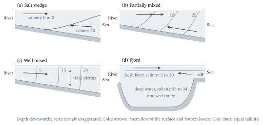
How sharply the two layers are separated depends on the contest between the river, which supplies the density difference, and the tide, which stirs it away. Figure 1 shows the four cases oceanographers distinguish:
- In a salt wedge estuary a large river meets a weak tide. The salt water lies under the fresh as a wedge with a sharp interface, tapering landward along the bottom, and the two hardly mix. The mouth of the Mississippi is the standard example; at low river flow its wedge reaches more than 100 km upstream.
- In a partially mixed estuary a moderate tide stirs the layers so that the salinity rises both along the estuary and downward, with sloping surfaces of equal salinity; Chesapeake Bay, the Thames, and most estuaries of the temperate coasts are of this kind.
- In a well mixed estuary a strong tide in shallow water stirs the whole depth, so the salinity changes along the estuary but hardly at all from the surface to the bottom, as in the estuaries of the Bay of Fundy and the Severn with their tidal ranges of 10 m and more (Unit 6).
- A fjord is a drowned glacial valley, deep in the middle and closed off from the sea by a shallow sill of rock or of moraine, the rubble a glacier left behind, at its mouth. A thin layer of brackish water flows out over the sill; the deep water below the sill depth is renewed only when dense water occasionally spills in over it. The Sognefjord in Norway is 1,308 m deep behind a sill 100 to 150 m below the surface.
1.1 Knudsen’s relations and the flushing time
How much water flows in and out of an estuary can be worked out without a single current meter, from the salinities alone. The argument was published in 1900 by the Danish physicist Martin Knudsen (1871-1949), who called it “a hydrographic theorem”, and it rests on two facts: in a steady state the water that enters a basin must leave it, and the salt that enters must leave it too, because salt is neither created nor destroyed in the sea.